File:Expedition 10.jpg
Jump to navigation
Jump to search

Size of this preview: 800 × 579 pixels. Other resolutions: 320 × 232 pixels | 640 × 463 pixels | 1,024 × 741 pixels | 1,280 × 927 pixels | 2,560 × 1,854 pixels | 3,856 × 2,792 pixels.
Original file (3,856 × 2,792 pixels, file size: 10.52 MB, MIME type: image/jpeg)
Captions
Captions
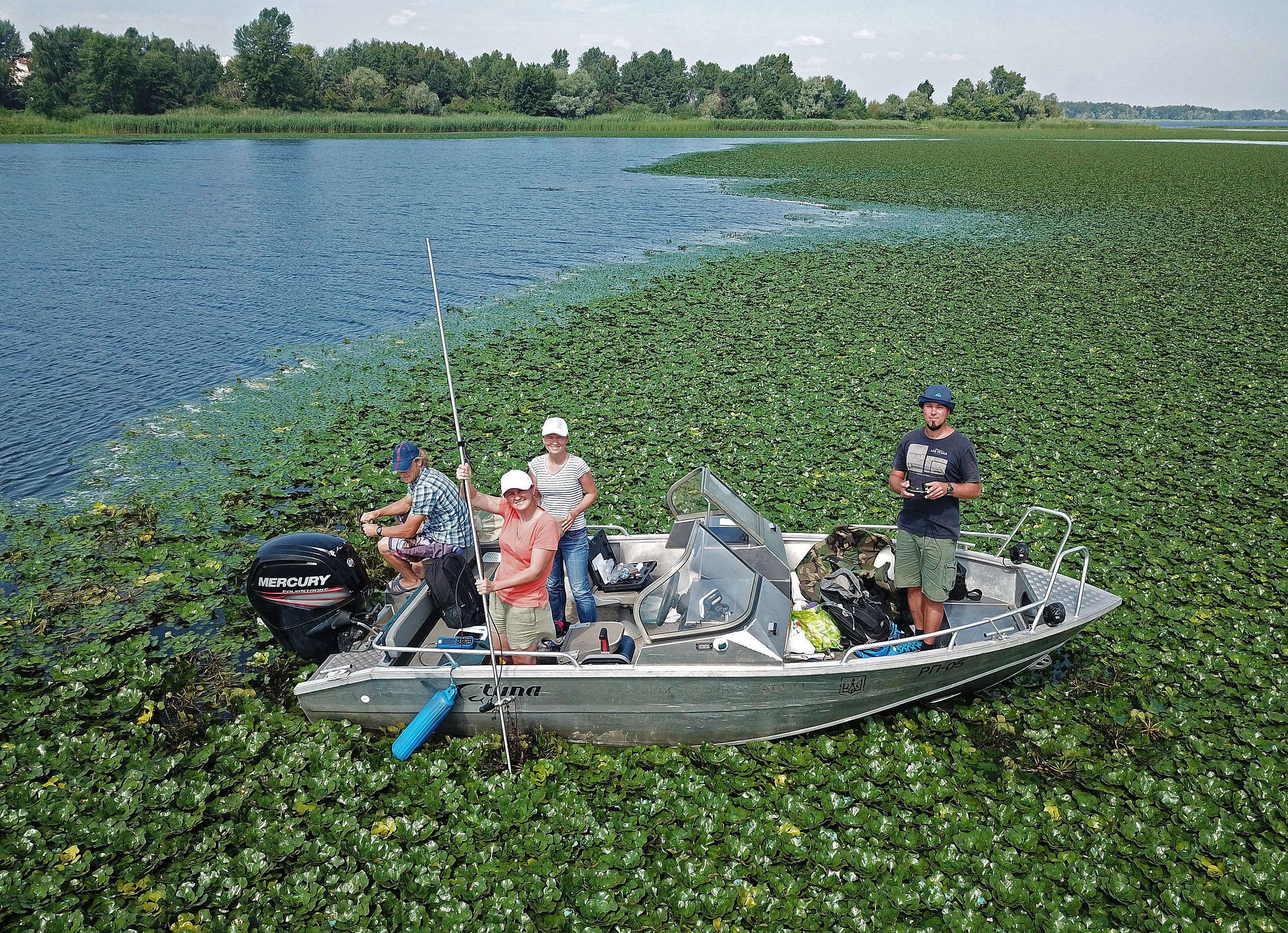
Photo complex research of young scientists taken from the drone Dji mavic pro.
Summary
[edit]
| Description |
Українська: Комплексне дослідження акваторії Канівського водосховища в зоні розповсюдження водяного горіху (Trapa natans L.) в серпні 2021 р. у рамках наукового проекту «Вплив заростання водосховищ вищими водними рослинами на процеси цвітіння та рибопродуктивність». Вчені Інституту Гідробіології НАНУ проводять батиметричні та фізикохімічні вимірювання, зокрема виміри швидкості течії з використанням приладу OTT MF pro Water Flow Meter, відбирають іхтіологічні зразки та проби води. Експерт з дистанційного зондування виконує картування території з БПЛА для валідації супутникових даних. Фото отримане за допомогою дрону Dji mavic pro (на висоті більше 30 м). English: Comprehensive study of the water area of the Kaniv Reservoir in the area of distribution of of the water nut (Trapa natans L.) in August 2021 in the research project " Influence of overgrowing reservoirs with higher aquatic plants on flowering processes and fish productivity". Scientists of the Institute of Hydrobiology of the National Academy of Sciences of Ukraine perform bathymetric and physicochemical measurements, in particular measurements of flow velocity using the OTT MF pro Water Flow Meter, take ichthyological samples and water samples. A remote sensing expert maps the area with a UAV to validate satellite data. The photo obtained with the drone Dji mavic pro drone (at a height of more than 30 m) |
| Date | |
| Source | Own work |
| Author | Bilous Olena |
| Camera location | | View this and other nearby images on: OpenStreetMap |
|---|
Licensing
[edit]
I, the copyright holder of this work, hereby publish it under the following license:
This file is licensed under the Creative Commons Attribution 4.0 International license.
- You are free:
- to share – to copy, distribute and transmit the work
- to remix – to adapt the work
- Under the following conditions:
- attribution – You must give appropriate credit, provide a link to the license, and indicate if changes were made. You may do so in any reasonable manner, but not in any way that suggests the licensor endorses you or your use.
| This image was uploaded as part of Science Photo Competition 2021 in Ukraine. |
File history
Click on a date/time to view the file as it appeared at that time.
| Date/Time | Thumbnail | Dimensions | User | Comment | |
|---|---|---|---|---|---|
| current | 17:33, 15 December 2021 | | 3,856 × 2,792 (10.52 MB) | Bilousolena (talk | contribs) | Uploaded own work with UploadWizard |
You cannot overwrite this file.
File usage on Commons
There are no pages that use this file.
File usage on other wikis
The following other wikis use this file:
- Usage on arz.wikipedia.org
- Usage on uk.wikipedia.org
- Usage on www.wikidata.org